
Mayor Carolyn Broullon has called a special meeting of the Borough for residents and other individuals to get the updated plans on the Flood Wall Project for the borough.
The meeting will be held Tuesday, May 14 at Henry Hudson Regional School, Grand Tour at 6 p.m. and gives the public the opportunity to learn more about the updated plans from the USACE Flood Wall Project.
The meeting is at the Henry Hudson gymnasium rather than Borough Hall to ensure the crowd anticipated for the hearing can be accommodated as well as to enable the Army Corps to use audio and visual equipment for their presentation.
Mayor Broullon has also assured borough residents the question of approving the Flood plan will be on the ballot in November.
The mayor was a member of council in 2017 when Council told the public at that time that the question of approving the flood risk management plan would be decided by the residents. Although she is the only member of that governing body still on the borough council, now as mayor, Broullon reiterated this week the question will be on the ballot this November.
Present at the meeting tomorrow night will be representatives of the US Army Corps of Engineers, the NJDEP, Highlands’ Professionals, and the Highlands Borough Council to hear comments and answer questions about the project. No formal action will be taken and the Engineer’s updated report will begin immediately after the roll call and Pledge of Allegiance.
The last Flood Risk Management Study report from the New York District of the Army Corp, with Bethany McClanahan P.E.CFM the project manager was in January, five months ago, and described the Highlands study area, approximately seven tenths of a square mile. The area under study is at the east end of the overall Raritan Bay and Sandy Hook Bay study area, bordered to the north by Sandy Hook Bay, the west by the corporate limits of Atlantic Highlands, and to the east by the Shrewsbury River and Route 36 bridge.
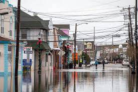
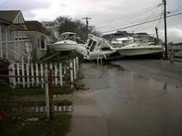
The Borough in the report is described as about 2,000 feet wide, and with flat topography for about 1,500 feet onshore from the bay, before rising rapidly to an elevation of 240 feet NGVD. A fully developed community with most year-round residences and commercial establishments located on the low-lying area along the bay. Highlands has a history of devastating flood damages. Approximately 880 residential, trailer home, apartment, and commercial structures are subject to severe flooding with approximately 670 located below 8 feet NGVD. Many low-lying roadways are flooded during severe storm events, cutting off access to large portions of Highlands. This area was devastated by Superstorm Sandy, the description continues.
The study was authorized by the Congressional Committee on Public Works and Transportation in 1990 with funding later provide by the Disaster Relief Appropriations Act of 2013, with construction authorized under the Water Resources Development Act.
In the January update, the Corps noted that the study was in response to flooding from back-to-back December 1992 Nor’easters. After feasibility studies were conducted and approved, the State Department of Environmental Protection concurred and approved a Feasibility Cost Sharing Agreement to share costs for further study. Completed work included a topographic survey and mapping, initial baseline studies, a structure inventory, and development of an existing conditions hydrology and hydraulics model. The information was shared with the public and time given over a two-month period in 2015 for further comment.


